Every farmer knows the feeling. You walk a field in mid-season, the crop looks reasonably healthy to the eye, and then the combine rolls in weeks later and the yield numbers tell a completely different story. The culprit, more often than not, was already there — hiding in plain sight, stealing water, nutrients, and light from your crop one square foot at a time.
Weeds do not announce themselves. They compete quietly and reproduce aggressively. By the time a weed problem is visually obvious from the ground, it has already cost you. The question facing producers across the Southern Plains, from the Texas Panhandle down through the Permian Basin and across into eastern New Mexico and western Oklahoma, is not whether weed pressure exists. It is whether you are finding it early enough and treating it precisely enough to protect your bottom line.
Multispectral drone imaging, combined with targeted drone-based prescription spraying, represents the most significant shift in weed management available to farmers today. At Tex-Air Drone, it is one of the core precision agriculture capabilities the company delivers to producers across Texas, Oklahoma, and New Mexico.
What Multispectral Imaging Actually Measures
Standard RGB cameras — the kind on your smartphone or a basic consumer drone — capture the same three channels of light the human eye sees: red, green, and blue. They are useful for visual documentation, but they cannot detect crop stress or weed pressure before it becomes visible.
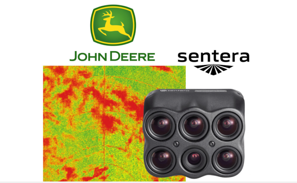
Multispectral sensors add additional bands of light that fall outside the visible spectrum, most critically near-infrared (NIR). Healthy, chlorophyll-rich plant tissue reflects NIR energy at a dramatically higher rate than stressed, senescing, or competing vegetation. By capturing and analyzing the ratio between red and NIR reflectance — a calculation known as the Normalized Difference Vegetation Index, or NDVI — agronomists and drone operators can produce detailed, color-coded maps of a field’s actual plant health status at any given moment.
The result is not a photograph. It is a data layer — one that reveals variation across thousands of acres that no ground scouting crew could realistically document with the same speed or spatial resolution.
Tex-Air Drone deploys advanced aerial multispectral sensors capable of detecting crop health, vigor, and stress levels before they are visible to the naked eye. That temporal advantage — catching a problem in its early stages rather than after it has compounded — is where the economic value lives.
Why Weed Detection Is One of the Highest-Value Applications
Weed management is one of the largest variable costs in dryland and irrigated crop production. Herbicide programs are expensive, and blanket applications across an entire field treat problem areas and clean areas exactly the same way. For producers managing thousands of acres of corn, sorghum, wheat, or cotton across the Southern Plains, that represents significant chemical spend directed at ground that does not need it.
Multispectral imaging solves this problem by making weed pressure spatially visible and economically actionable.
Weeds that have established within a crop canopy show distinct spectral signatures from surrounding crop plants. Their reflectance patterns differ based on leaf structure, growth stage, and species characteristics. When a multispectral drone flight captures these differences across an entire field, the resulting imagery can be processed into a weed-pressure map that identifies not just where weed pressure exists, but at what density and, in many cases, at what growth stage.
From that map, Tex-Air Drone’s precision agriculture capabilities take the next logical step: generating variable rate prescription maps that specify exactly which zones require treatment and at what application rate. Those prescription maps can be downloaded directly to spray drones or ground equipment to execute a targeted, zone-specific application rather than a blanket pass across the field.
The economic implications are significant. Reducing herbicide spend by treating only the areas that need treatment, rather than broadcasting product across an entire field, is a direct input cost reduction. When that reduction is compounded across multiple fields and multiple seasons, the return on the cost of aerial imaging becomes straightforward to calculate.
The Weed Pressure Reality Facing Southern Plains Producers
Producers across the Texas Panhandle, the South Plains, eastern New Mexico, and western Oklahoma are managing weed challenges that have grown more complex over the past decade. Palmer amaranth — commonly called pigweed in the region — is among the most economically damaging and herbicide-resistant weeds in U.S. row crop production. Kochia, marestail, and various grass species round out a weed complex that requires timely, accurate scouting and increasingly targeted application strategies.
Traditional ground scouting cannot keep pace with this problem at scale. A trained agronomist walking transects through a 5,000-acre cotton or corn operation can provide valuable qualitative insight, but the spatial coverage is inherently limited, and the time required to complete a full-field assessment creates a lag between detection and treatment that weed biology does not forgive.
A multispectral drone flight over the same 5,000 acres can be completed in a fraction of the time it would take to ground-scout a fraction of that acreage. The resulting prescription map is available for analysis within hours of the flight. Treatment can begin the same day or the next morning, at the precise locations and rates the data indicates.
This speed-to-data-to-action pipeline is the defining advantage of aerial precision agriculture over traditional scouting and spray programs.
How Tex-Air Drone Delivers This Capability Across the Region
Tex-Air Drone was established with a specific geographic focus: serving the producers, ranchers, and industrial clients of Texas, Oklahoma, and New Mexico. The company operates dedicated offices in West Texas, East Texas, and North Texas — a footprint designed to keep response times short and local knowledge deep.
The team backing these services brings genuine agricultural credibility. Operations Manager Ben Burks holds a B.S. in Agricultural Business and Economics and brings hands-on ranching and 4-H livestock experience. Pilot Jon Tolleson is a Certified Crop Advisor with 40 years of farming experience in Hutchinson and Moore Counties — growing corn, sorghum, wheat, and cattle in exactly the region where much of this work is performed. This is not a team learning agriculture from the outside. These are people who understand what a stand failure costs and what a weed pressure problem looks like before it shows up in the yield data.
That ground-level agricultural knowledge is applied through advanced aerial platforms and data-processing partnerships. Tex-Air Drone works with industry partners including Sentera — a precision agriculture company known for its multispectral sensors and field-analysis software — as well as Pix4D for photogrammetric processing and AgTech Solutions Group for data integration. These partnerships ensure that the data captured in the field is processed through industry-validated workflows and delivered in formats that are immediately actionable.
From Imaging to Prescription: A Practical Workflow
Understanding the step-by-step process clarifies why this service delivers value beyond simple aerial photography.
Step 1: Pre-flight planning and field data intake. Before a flight, Tex-Air Drone works with the producer to understand the field’s history — what crops are in the ground, what weed species have been historically problematic, what herbicide programs have been used, and what the producer’s operational constraints are.
Step 2: Multispectral imagery capture. The drone is deployed to fly a systematic grid pattern over the target field at an altitude and ground sampling distance appropriate for the analysis being conducted. Multispectral data is captured in multiple spectral bands simultaneously.
Step 3: Data processing and index calculation. Captured imagery is processed through photogrammetric and spectral analysis software. NDVI and other vegetation indices are calculated and used to generate georeferenced field maps showing health variability across every acre.
Step 4: Weed pressure identification and zone mapping. Processed data is analyzed to identify areas of anomalous reflectance consistent with weed pressure, off-type vegetation, or stress zones. These areas are delineated into treatment zones.
Step 5: Variable rate prescription generation. A prescription map is generated that specifies application rates by zone. Areas with high weed density receive full-rate treatment. Areas with low or no weed pressure are excluded or treated at reduced rates.
Step 6: Application via drone or ground equipment. The prescription can be downloaded directly to Tex-Air Drone’s spray drone fleet for aerial application, or exported in a format compatible with variable rate ground applicators. The producer chooses the execution method that fits their operation.
Step 7: Post-application verification. Follow-up imaging confirms application coverage and treatment efficacy, providing a documented record of the management intervention.
Multispectral Imaging Beyond Weed Detection
While weed management represents one of the clearest return-on-investment use cases for multispectral imaging, the same flight and dataset can simultaneously reveal additional field management information.
Stand count analysis — identifying bare spots, thin emergence zones, or skip areas in a planted field — is captured in the same data. Irrigation uniformity issues manifest as stress patterns visible in NDVI maps before they progress to visible wilting. Nutrient deficiency zones, particularly nitrogen stress in corn and sorghum, show early spectral signatures that ground observation would miss for days or weeks.
This multi-use character of a single multispectral flight compounds the return on the investment in imaging. A producer is not paying for weed detection alone — they are receiving a comprehensive aerial health assessment of their crop that informs multiple management decisions simultaneously.
Tex-Air Drone’s agricultural service menu includes stand count analysis, multispectral imaging, variable rate prescription generation, and drone spraying as integrated capabilities — meaning the same provider that flies the imaging mission can also execute the treatment, delivering a seamless data-to-application workflow that minimizes coordination overhead for the producer.
The Cost Conversation: What Precision Weed Management Actually Saves
The economic case for multispectral imaging and precision weed management is built on three categories of savings.
Reduced herbicide spend. When variable rate prescriptions target only zones where weed pressure is confirmed, blanket broadcast applications are replaced by targeted treatments. For fields where weed pressure is spatially concentrated — a common pattern, particularly along field margins, irrigation risers, and compacted zones — the reduction in total product applied can be substantial.
Reduced resistance development. Reducing the volume of herbicide applied to a field reduces the selection pressure that drives resistance evolution. For producers already managing resistant Palmer amaranth populations, any tool that slows the development of additional resistance has long-term agronomic value beyond the immediate cost savings.
Earlier detection, lower treatment cost. Treating small weed plants is less expensive than treating large, established weed plants. Smaller weeds require lower application rates to achieve effective control. Multispectral imaging enables detection at early growth stages, before weed plants have reached the size at which they become harder — and more expensive — to control.
Getting Started With Multispectral Weed Management
For producers in Texas, Oklahoma, or New Mexico who have not yet incorporated aerial multispectral imaging into their crop management program, the entry point is straightforward. Tex-Air Drone provides project-specific quotes based on acreage, target crops, and the scope of analysis required.
The company’s service area spans West Texas, East Texas, North Texas, eastern New Mexico, and western Oklahoma — regions defined by the large-scale row crop, cotton, and forage operations where the economics of precision weed management are most compelling.
Weed pressure does not wait for a convenient scouting window. The fields that will see the greatest benefit from multispectral detection are the ones where the problem is already developing — quietly, below the threshold of what a ground-level observation will catch until the opportunity for low-cost early intervention has passed.
Tex-Air Drone exists to close that gap: putting actionable aerial data in the hands of producers while the data can still change outcomes. To discuss multispectral imaging and weed detection services for your operation, contact Tex-Air Drone at 806-318-1825 or request a quote at texairdrone.com.
Tex-Air Drone provides precision agricultural drone services — including multispectral imaging, weed detection, variable rate prescription generation, stand count analysis, and drone spraying — to producHomeers across Texas, Oklahoma, and New Mexico. The company operates offices in West Texas, East Texas, and North Texas.