There is a particular kind of knowledge that comes from working the same land for decades. A rancher who has walked the same pastures across thirty or forty seasons develops a feel for the terrain — where the moisture pools after a rain, which draws go dry first in a drought, where the grass thins out along the caliche flats. That knowledge is irreplaceable. What drone technology offers is not a replacement for that experience. It is a force multiplier that lets one operation accomplish in hours what previously required days, crews, and equipment costs that could stack up fast enough to kill a thin margin.
Across Texas, Oklahoma, and New Mexico, ranching operations face a persistent pressure: land is vast, labor is expensive and increasingly hard to find, and the inputs required to maintain productive pasture — seed, fertilizer, herbicide — represent significant costs that need to be applied as efficiently as possible to justify the spend. Aerial drone services are changing the economics of those inputs in a way that fixed-wing aircraft never could, because drones operate at a scale and precision that fits the realities of modern ranch management.
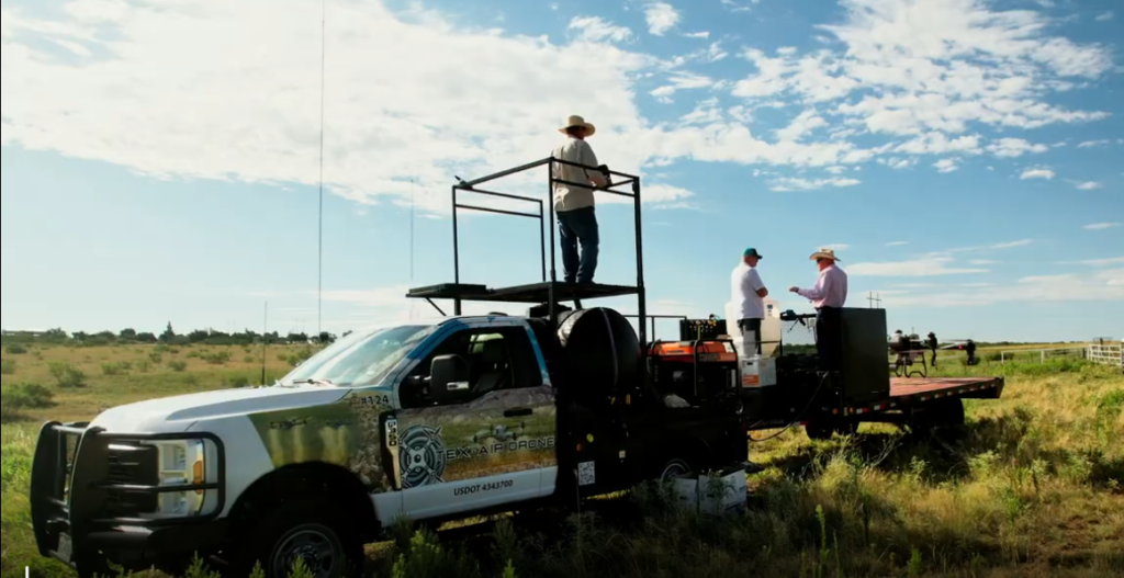
Tex-Air Drone, serving producers across West Texas, East Texas, North Texas, eastern New Mexico, and western Oklahoma, provides the aerial capabilities that ranchers in this region are increasingly using to cover more acres, reduce input waste, and make land management decisions backed by actual data rather than best estimates.
The Scale Problem Every Rancher Knows
A ranch in the Texas Panhandle or the South Plains is not a small operation. Many run tens of thousands of acres, with pastures that can be ten, twenty, or thirty miles from the nearest paved road. Assessing the condition of those pastures — forage density, weed encroachment, bare soil exposure, water distribution — requires either boots on the ground across impossible distances or the kind of aerial perspective that puts an entire section in a single frame.
Traditional approaches have involved fixed-wing aircraft or helicopters for aerial scouting, both of which are expensive to mobilize, difficult to deploy on short notice, and incapable of the kind of low-altitude, precision data capture that modern drone platforms deliver. For broadcast seeding or fertilizer applications, ground equipment on native range pastures means soil compaction, brush interference, and the practical impossibility of reaching wet or rugged terrain after a weather event — often exactly the window when an application would be most effective.
The drone fills that operational gap. It accesses terrain that ground equipment cannot, operates at a cost point well below manned aircraft, and delivers data — or inputs — with a spatial precision that neither a ground operator nor a fixed-wing pilot can match.
Broadcast Seeding by Drone: Timing the Application You Could Not Make Before
Pasture reseeding is one of the highest-leverage investments a rancher can make in the long-term productivity of native or improved range. The economics are straightforward: a well-stocked stand of grass supports more animal units, reduces erosion, retains more moisture, and depresses weed pressure. The challenge has always been getting seed on the ground at the right time, in the right condition, in locations that ground equipment cannot practically reach.
Drone broadcast seeding changes that calculus in several important ways.
Post-rain deployment windows. Across much of the Southern Plains, the optimal window for seeding is a narrow one — typically immediately following a rain event while the soil surface retains moisture. Ground equipment deployment during or immediately after a rain is often impractical: wet, heavy soil compacts badly under wheel traffic, and brush-heavy terrain becomes impassable. A drone can be airborne within hours of a rain, placing seed on moist, receptive ground without any of those mechanical constraints.
Terrain access. Native range in West Texas, eastern New Mexico, and Oklahoma includes draws, breaks, cedar-choked hillsides, and rocky flats that no grain drill or broadcast spreader will reach on a practical basis. Drone deployment is terrain-agnostic in a way that no ground equipment can match. The drone does not care whether the target is a flat center-pivot field or a rough cedar draw that hasn’t been successfully seeded in twenty years.
Targeted application. Rather than broadcasting seed across an entire pasture regardless of existing stand density, drone-supported seeding informed by aerial imagery can concentrate seed placement in the zones where stand gaps are most severe. That targeting reduces total seed spend and improves establishment rates by directing inputs to where they are most needed.
Tex-Air Drone’s agricultural services include drone broadcast seeding as a core capability — a direct reflection of the realities facing ranching operations across the region the company serves.
Drone Fertilizer Application: Getting Nutrients Where Ground Equipment Cannot
The economics of fertilizing native or improved pasture have always hinged on the cost of application relative to the yield response. When fertilizer prices are elevated — as they have been through much of the current decade — the margin for inefficient application narrows to nothing. Broadcast application across an entire pasture, regardless of where the existing forage stand is thin or where nutrient deficiency is most acute, is an approach that wastes product on ground that may not respond and misses the areas where the investment would pay back most.
Drone fertilizer application delivers the same fundamental advantage that drone precision agriculture delivers in row crops: the ability to apply inputs at rates and locations informed by actual field data rather than uniform assumptions.
A multispectral imaging flight over a pasture before fertilizer application produces a vegetation index map that shows, at spatial resolution, where forage vigor is strong, where it is stressed, and where bare areas indicate stand failure or severe overgrazing pressure. That map informs a variable rate fertilizer prescription — just as it does in a corn or cotton field — that concentrates product in the zones most likely to respond, reduces application rates in areas with strong existing stands, and skips areas where stand failure is so severe that fertilizer alone will not produce a yield response.
The result is the same whether the target crop is corn or coastal bermudagrass: less product applied, better-targeted application, and documented data showing where, when, and how much was applied across every acre.
For ranchers running large acreages of improved pasture — coastal, bermudagrass, kleingrass, or introduced cool-season species — this precision approach to fertilization is one of the clearest return-on-investment cases in the drone services portfolio.
Aerial Land Assessment: Building a Data Record for Every Acre
One of the most underutilized applications of drone technology in ranch management is systematic aerial documentation — not for any single management decision, but as the foundation of a long-term land record that accumulates value over time.
A ranch is a complex, dynamic system. Vegetation communities shift across years and decades in response to rainfall patterns, grazing pressure, fire history, invasive species encroachment, and natural succession. The decisions that shape a ranch’s long-term productivity — stocking rate adjustments, brush management investments, water infrastructure placement, pasture rotation changes — are best made when they can be compared against documented historical conditions rather than memory and intuition alone.
Tex-Air Drone’s aerial mapping capabilities, which produce high-resolution orthomosaic maps and elevation models from nadir, oblique, and facade imaging, are directly applicable to this kind of systematic land documentation. A ranch that commissions an annual or biannual aerial mapping flight builds a chronological record of its land conditions that becomes increasingly valuable over time. Brush encroachment can be measured. Bare ground expansion can be tracked. Water distribution across a pasture can be evaluated against elevation data. The spatial record that accumulates from regular flights supports management decisions that no amount of ground observation can inform as comprehensively.
For ranches with significant infrastructure — water wells, storage tanks, pipelines, fence lines, pens, and working facilities spread across large acreage — aerial mapping also provides an up-to-date spatial inventory that simplifies maintenance planning, supports insurance documentation, and provides the kind of as-built record that is invaluable when a property changes hands or when a significant capital improvement is planned.
Weed and Brush Management: Identifying the Problem at Scale
Prickly pear encroachment. Juniper expansion. Mesquite thickening along draws and fence lines. Invasive annual grasses replacing native perennial species. These are not abstract threats to ranchers in the Southern Plains — they are active, ongoing land management challenges that represent significant capital expenses when treatment is required.
The challenge with brush and weed management on native range is identification and prioritization. A 20,000-acre ranch may have brush encroachment problems across dozens of distinct locations at varying stages of development. Knowing where to prioritize mechanical treatment, aerial herbicide application, or prescribed fire requires a spatial understanding of the problem that ground observation across that acreage simply cannot efficiently provide.
Aerial drone flights — both RGB mapping flights for visual documentation and multispectral flights for vegetation stress analysis — produce the spatial data needed to triage a brush management program. Dense juniper canopy reflects differently in NIR bands than native grass beneath it. Prickly pear patches appear in high-resolution orthomosaic imagery with enough clarity to support area calculations for treatment cost estimation. Encroachment along fence lines and water sources can be documented and tracked across years.
That documentation supports not just operational planning but also conservation program applications, where documented brush encroachment conditions and treatment outcomes are often required to qualify for cost-share assistance through USDA programs — a practical financial consideration for Texas, Oklahoma, and New Mexico ranch operations that participate in the Environmental Quality Incentives Program (EQIP) or the Conservation Reserve Program (CRP).
The Team Behind the Technology: Agriculture Is Not a New Subject Here
Technology is only as valuable as the people deploying it understand the problem it is solving. Tex-Air Drone’s team brings genuine agricultural depth that is directly relevant to ranch management applications.
Operations Manager Ben Burks holds a Bachelor of Science in Agricultural Business and Economics with a focus in Animal Science, and his background includes hands-on ranching through his family’s operations — an experience base that shapes how the company approaches land management projects. Pilot Jon Tolleson is a Certified Crop Advisor with four decades of farming and ranching experience in Hutchinson and Moore Counties in the Texas Panhandle, growing corn, sorghum, wheat, and cattle in the same geographic and climatic context where many of Tex-Air Drone’s ranch clients operate.
When a rancher in the Texas Panhandle describes a weed pressure problem or a reseeding challenge, Tex-Air Drone’s team understands the agronomic context behind it — not because they learned it from a brochure, but because they have worked in that landscape.
That operational credibility is reflected in how the company’s clients describe their experience. Customers have noted the team’s attention to property boundaries and neighboring landholders during application operations — the kind of professional discipline that matters on a ranch where spray drift onto a neighbor’s field or water source is not an abstract risk but a real operational and relationship concern.
Serving the Southern Plains Ranch and Land Management Market
Tex-Air Drone operates with dedicated offices in West Texas, East Texas, and North Texas, serving a service territory that spans the full geographic range of Southern Plains ranch country. West Texas and eastern New Mexico operations cover the ranching-intensive regions of the Permian Basin, the Trans-Pecos, and the Rolling Plains. North Texas coverage extends into the Cross Timbers and western Oklahoma rangelands where brush encroachment and pasture management are perennial concerns. East Texas coverage addresses the improved pasture and timber land management sector where drone applications are an increasingly important management tool.
The company’s partner network supports the data processing and precision application capabilities that ranch management applications require. ROCK Robotic provides LiDAR hardware that supports the precision terrain modeling useful for water distribution analysis and infrastructure planning on large acreages. Sentera’s precision agriculture platform supports multispectral analysis for vegetation assessment. Pix4D’s photogrammetric processing workflows produce the high-accuracy mapping outputs that make aerial land documentation genuinely useful for management planning rather than simply impressive-looking imagery.
What a Drone Service Engagement Looks Like for a Ranching Operation
For ranchers who have not previously worked with a commercial drone service provider, the practical question is often how an engagement actually works — what the process looks like, what data or decisions come out of it, and what the timeline is from initial contact to completed work.
Tex-Air Drone’s process begins with a project scoping conversation to understand the specific management objectives: Is the goal a one-time imaging flight to assess pasture condition? A broadcast seeding application following a rain event? A regular monitoring program to track long-term land condition trends? The scope of the engagement shapes the flight planning, data processing, and deliverable format.
For application-focused work — seeding or fertilizer — the company’s relationship with Sentera and its precision agriculture software supports the generation of variable rate prescriptions from imaging data, and those prescriptions can be loaded directly into drone application systems for execution. For mapping and documentation work, Pix4D-based processing workflows produce georeferenced orthomosaic maps and elevation models delivered in formats compatible with standard GIS software and farm management platforms.
From initial contact to completed flight and delivered data, the timeline depends on project scope and weather conditions, but Tex-Air Drone is structured to respond quickly to weather-dependent deployment windows — the kind of post-rain seeding opportunity that waits for no one.
The Ranch Is Still Yours. The Data Makes It More Productive.
Drone technology does not change what a ranching operation is or what it requires. It does not replace the judgment that comes from decades of working a specific piece of land. What it does is put more and better information in front of the people making the decisions — faster, at lower cost, and at a spatial scale that ground observation cannot match.
For ranching operations in Texas, Oklahoma, and New Mexico managing large acreages with limited labor and tight input margins, the practical value of that information is concrete: seed placed at the right time on ground that will actually germinate it, fertilizer directed to pasture that will respond to it, brush encroachment mapped and prioritized before it becomes a full-scale reclamation problem, and a land record that documents every significant management intervention across the life of the operation.
Tex-Air Drone provides these capabilities across the Southern Plains, backed by a team with the agricultural experience to understand what the data means and the technical capability to capture it accurately. To discuss aerial services for your ranching or land management operation, contact Tex-Air Drone at 806-318-1825 or request a project quote at texairdrone.com.
Tex-Air Drone provides commercial drone services — including broadcast seeding, drone fertilizer application, multispectral land assessment, aerial mapping, and precision agriculHometure — to ranching and land management operations across Texas, Oklahoma, and New Mexico. The company operates offices in West Texas, East Texas, and North Texas.