In an era where “time is money” and “accuracy is everything,” the traditional way of viewing a project site—from the ground or through outdated satellite imagery—is no longer enough. To truly manage complex projects, teams are turning to a highly accurate 3D digital twin to visualize physical sites digitally. To truly manage a farm, a construction site, or an industrial facility, you need a bird’s-eye view that provides more than just a pretty picture.
At Tex-Air Drone, we specialize in high-resolution 2D Orthomosaic Mapping and 3D Digital Twin Modeling. These aren’t just photos; they are data-rich environments that allow you to measure, plan, and execute with absolute certainty.
Whether you are calculating the volume of a stockpile in Amarillo or scouting crop health in the Coastal Bend, here is how our mapping services are changing the game.
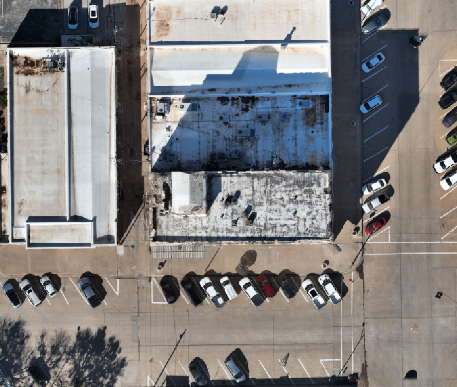
1. 2D Orthomosaics: The Ultimate Site Map
Standard aerial photography has a major flaw: perspective distortion. The further an object is from the center of the camera lens, the more tilted it appears. An Orthomosaic fixes this.
By stitching together hundreds (sometimes thousands) of individual nadir (top-down) photos and correcting them for topographic relief and lens distortion, Tex-Air Drone creates a single, massive, high-resolution image.
Why 2D Mapping is Essential:
- True-to-Scale Measurements: Unlike a Google Earth screenshot, our orthomosaics are geometrically corrected. You can measure distances, areas, and perimeters directly on the map with sub-centimeter accuracy.
- Instant Site Documentation: For construction managers, a weekly 2D map provides an undeniable “paper trail” of progress, helping to resolve subcontractor disputes and verify work completion.
- High-Definition Crop Scouting: Our drones capture imagery at a resolution satellite providers simply can’t match. We can see individual rows, irrigation leaks, and localized pest pressure before they become field-wide disasters.
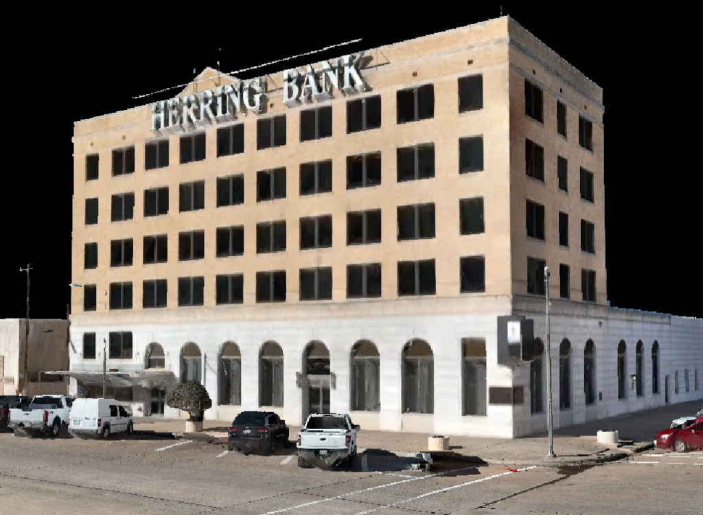
2. Creating a 3D Digital Twin Model for Your Site
While 2D maps tell you where things are, 3D Models tell you what they are. Using advanced photogrammetry and LiDAR technology, Tex-Air Drone generates immersive 3D reconstructions of buildings, stockpiles, and terrain.
The Power of the 3D digital twin:
- Volumetric Analysis: For industrial and construction clients, calculating the volume of gravel, topsoil, or mineral stockpiles used to take days of manual surveying. We can do it in minutes of flight time, providing accurate cubic-yardage reports that keep your inventory lean and precise.
- Structural Inspections: An asset-mapped 3D digital twin allows stakeholders to “fly” around a structure—like a grain elevator or a communication tower—from their office chair. You can zoom in on specific bolts, welds, or cracks without ever leaving the ground.
- BIM Integration: These detailed models serve as the foundation for Building Information Modeling (BIM), allowing architects and engineers to overlay new designs onto the current “as-built” reality of the site. To learn more about advanced data conversions, see our in-depth guide on BIM and planimetric engineering workflows.
3. Topographic Mapping and Contour Lines
Understanding the “lay of the land” is critical for drainage planning, terracing, and foundation work. Tex-Air Drone converts drone mapping data into Topographic Maps with detailed contour lines.
- Drainage Management: For farmers, knowing exactly how water moves across a field can prevent erosion and optimize irrigation.
- Site Preparation: For developers, our topo maps identify high and low spots that require grading, helping to provide accurate earthwork estimates before the first bulldozer arrives on site.
4. Visualizing Change Over Time with a 3D Digital Twin
One of the most underutilized benefits of drone mapping is Temporal Analysis. By rendering a recurring 3D digital twin along the exact same flight path at regular intervals (monthly, quarterly, or seasonally), we provide a “time-machine” for your assets.
- For Ranchers: Watch the recovery of grazing lands after a rotational shift.
- For Solar Farms: Monitor the accumulation of dust or debris on panels over time to optimize cleaning schedules.
- For Construction: Create compelling time-lapse visuals for stakeholders and investors to show project milestones being met.
5. Why Choose Tex-Air Drone for Your Mapping Needs?
Data is only useful if it’s accurate. At Tex-Air Drone, we don’t just “point and shoot.”
- Ground Control Points (GCPs): We use high-precision GPS hardware on the ground to “anchor” our maps to the real world, ensuring that your digital measurements match your physical site perfectly.
- Actionable Deliverables: We deliver files in the formats you actually use—TIFF, SHP, DXF, OBJ, and more—making integration into your existing CAD or GIS software seamless.
- Texas-Grown Expertise: Based in Amarillo, we understand the specific environmental challenges of the region, from high winds to dusty conditions, ensuring we get the job done right the first time.
Conclusion: Stop Guessing, Start Mapping
In the modern landscape, relying on old data is a liability. Whether you need a 2D orthomosaic for a legal boundary check or a high-precision 3D digital twin for a complex engineering project, Tex-Air Drone provides the clarity you need to move forward with confidence.
Ready to see your property like never before? Experience the “Spray and Slay” difference in every pixel.
[Request a Consultation or Quote Today] Phone: (806) 318-1825 Email: read@texairdrone.com