Soil type changes across a few hundred feet, moisture distribution is uneven, weed pressure concentrates in certain zones.

The science behind herbicides, fungicides, and fertilizers helps, but are applied equally across that varied landscape. Every input dollar spent on the wrong acre is a dollar that didn’t move the yield needle. That difference is where precision agriculture technology earns its place on a modern farm operation.
Even experienced eyes cannot replace the actual data from multispectral imaging. Beyond large research institutions or early-adopter showcase farms, variable rate applications (VRA) have developed into a practical solution for all farm operations. Not just for Tex-Air Drone delivers this workflow across its service territory; Texas, New Mexico, and Oklahoma.
1. VRA Starts With Seeing What Uniform Applications Miss
We map each farm crop relevant to management into zones before any product is applied.
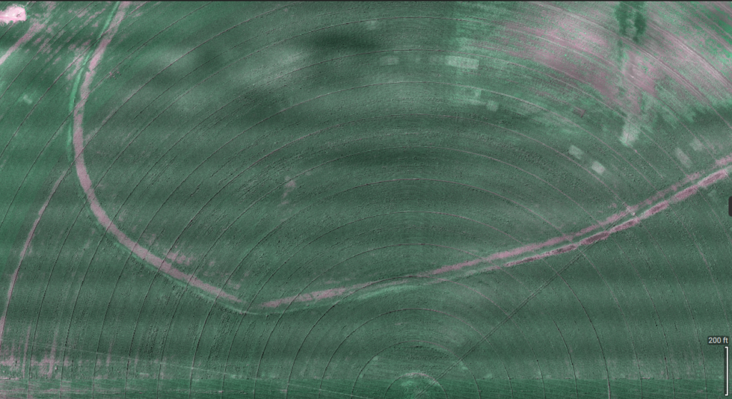
Multispectral imaging uses NDVI and NDRE across each acre, creating a vegetation index map that shows crop vigor and stress signs. It also shows weed pressure zones and bare-ground areas. This map defines the prescription for the drone. It tells the drone where to spray and how much to apply.
Tex-Air Drone’s precision agriculture services begins with multispectral imaging as an integrated component of VRA programs that feeds directly into prescription generation and application execution.
2. VRA Prescriptions Put Chemistry Where It Performs
The field data layer drives a prescription map that sprays where weed pressure tends to build up. This often happens along field margins and around irrigation equipment and in compacted zones near traffic patterns. It may appear in rough terrain where tractors and ATVs cannot reach. The map reduces rates or skips areas where the existing stand is clean improving the environmental impact of chemicals.
3. VRA Through Prescription Maps Eliminates Guesswork
The traditional approach to field-wide input application uses only a few data points – a soil sample here and a scouting observation there applied across the entire acreage. Even experts can miss small changes in space that drive whether an input investment delivers the yield gain it was meant to produce.
For producers who have used the same blanket rates for years, some field areas may still underperform. If you wonder why smart ag, using a VRA and prescription map can help. It can reveal spatial answers that uniform programs may hide.
4. VRA at Scale Compounds Savings Season Over Season
The financial case for VRA is strongest when it is viewed as a multi-season program, allowing the evolved data to define each season’s prescription cycles reflecting field performance patterns.
Three to five seasons’ worth of history achieves what no amount of experience-based intuition can fully replicate, making for better planning decisions, input purchasing, and a continuously improving prescription that reflects not just this season’s conditions but the full agronomic pattern of the field.
The flight data is the record. The prescription is the output. The VRA is the action. And the yield data that follows is the feedback loop that makes the next season’s prescription better than this one.
Smart Farming Is Not Just for Large Operations
There’s some truth that setup cost and complexity made early precision farming technology scale best for large operations, but not today. Rather than buying and learning how to operate a drone with a multispectral sensor, any sized producer can benefit with VRA from Tex-Air Drone.
And for operators who think the technology is as cool as we do and eventually want to do it themselves, Tex-Air Drone can advise and sell the proper equipment, and get you going…drones can also be used for finding cattle, and any number of hobby/fun applications.
Getting A VRA Into Your Operation
For producers who have not yet incorporated VRA into their farming program, the practical starting point is a single imaging flight over the acreage where input efficiency feels least predictable — the field where some sections always respond and others never seem to justify the spend. That first flight establishes the baseline that drives the first prescription, and the savings identified in that prescription typically provide the clearest financial case for expanding the program to additional acreage.
Tex-Air Drone’s team works with producers across the Southern Plains to design data driven VRA program that fits their specific crop, input challenges, and acreage profiles. Texas A&M AgriLife Extension’s precision agriculture resources provide additional background on how precision application technology fits into broader farm management programs for Texas producers. Get a variable rate application quote from Tex-Air Drone to start the conversation. You can also check Tex-Air Drone’s Texas, Oklahoma, and New Mexico service area to confirm coverage for your location.
Frequently Asked Questions
What is variable rate application in precision agriculture? VRA is applying inputs like herbicide, fertilizer or fungicide at different rates across a field.
It uses data to match each zone’s needs, instead of using one uniform rate for the whole field.
How does a precision ag drone execute variable rate application? A precision ag drone first captures multispectral images that show field variation and then processed into a prescription map. The map assigns specific rates to specific zones. That prescription is loaded into a drone, which automatically adjusts application rate as the aircraft flies across the field.
Does variable rate application work for both herbicide and fertilizer programs? Yes — a VRA can be used for any liquid input. It works best when field zones need different rates. Herbicide, fertilizer, fungicide, and liquid micronutrient programs all benefit from VRA where data collection supports zone-specific prescriptions.
Tex-Air Drone provides precision agriculture drone services — including variable rate application, multispectral imaging, prescription mapping, and aerial spraying — to row-crop and ranching operations across Texas, Oklahoma, and New Mexico. In addition to our aerial services, we offer the sale of DJI drones and parts, PIX4D software, and Sentera sensors. The company operates dedicated offices in West Texas, East Texas, and North Texas.
☎️806-318-1825